Deleted
Deleted Member
Posts: 0
|
Post by Deleted on Mar 14, 2019 12:22:51 GMT -5
Maybe this question will appear stupid to some people... Now I will begin with landscape and I wanna know if, and how, I can build a (perpendicular) railroad crossing with my track which has a slope of 1.6% ; near the track the road must be oblique, must "lean" (in fact, only 0.64 mm height difference for a road of 4 cm width, a "country road") ; I think I should build a slight helicoidal transition from a "flat" to an "oblique" road ; or is there any way how the problem is solved on prototypical railroads, I think it can occur ... or do "they" avoid it ? Thanks for any answer.
|
|
|
|
Post by markm on Mar 14, 2019 13:12:19 GMT -5
The rules can get complicated and depends on the state ad era you're modeling and since I don't have access to my books today I won't try to state them from memory. But it can all be summarized by a common sense rule: approaching traffic must be able to see the train or a active monitoring signal in time to stop at the posted speed limit. Otherwise the crossing is marked as "stop-look-listen."
In my neighborhood there are some rather steep (4-5%0 road crossing at about a 30-45 degree angle. May I suggest you take a look at the crossing at Highway 88 and Brook Ranch Rd. in Ione CA and the crossing on Highway 88 East of Sutter Creek Ranch Rd. as extreme examples of what you want to model. Sorry, I don't seem to be able to get the map URL to load correctly.
Hope this helps,
Mark
|
|
Deleted
Deleted Member
Posts: 0
|
Post by Deleted on Mar 14, 2019 13:26:42 GMT -5
Thanks Mark but : 1) I think You are speaking about Google maps, earth and so on : I have issues to acess them. 2) I wonder if my explanation was clear : the road has NO "LONGITUDINAL" SLOPE, it's the track which has it. So at the crossing the road will get "lateral" slope ... 3) I think that, according to the location of the crossing, it would be secured (prototypically) by blinking lights ...
|
|
|
|
Post by smr on Mar 14, 2019 13:31:29 GMT -5
I don't know if that helps you with your issue, but here are two railroad crossings we modeled on Niles Junction;   Best, Sven |
|
Deleted
Deleted Member
Posts: 0
|
Post by Deleted on Mar 14, 2019 13:58:31 GMT -5
Thanks, Sven, for the pictures. The first thing I notice on them is that the "geometric" problem is not very important, nobody would worry about a "lateral" slope of the road ... The second one is that Your roads have no asphalt : would this be OK for the East Coast in the 60's ? And thanks for the "St Andrew's crosses" with the lights on the first picture ...
|
|
|
|
Post by smr on Mar 14, 2019 14:04:48 GMT -5
In the 60ties at the Eastcoast, for sure! Here you see quite nicely how we model the road up to the level of the tracks:  Here with asphalt:  Hope this helps! Best, Sven |
|
|
|
Post by smr on Mar 14, 2019 14:20:57 GMT -5
Modern road of the 60ties with asphalt coverage:  |
|
Deleted
Deleted Member
Posts: 0
|
Post by Deleted on Mar 14, 2019 15:20:05 GMT -5
Thanks, the last picture with the US steam loco seems the most interesting and, despite of the fact that the track has no slope, I saw that the left edge of the road in front of the track is a little bit higher ...  and it causes no issue to anybody. The last picture of all is unfortunately the less interesting, I saw a German steam loco, and so I think it is a German layout ... or is it the same, only with an other looking angle and some different vehicles ?  |
|
|
|
Post by markm on Mar 14, 2019 16:08:40 GMT -5
I generally use the Bing engines (Microsoft branded Yahoo) as I too have issue with Google. Beside the fact that I'm familiar with these crossings, they are sort of a worst case example. Both the road and the track are on a grade (about 4% and 1% respectively) both the road and track are on curves and cross obliquely and neither the road or track has changed much since about 1950. The crossing was electrified about 1970 at which point the speed limit was raised from 25MPH to 55MPH. Finally, I ran across a good image of the approach to a grade crossing: 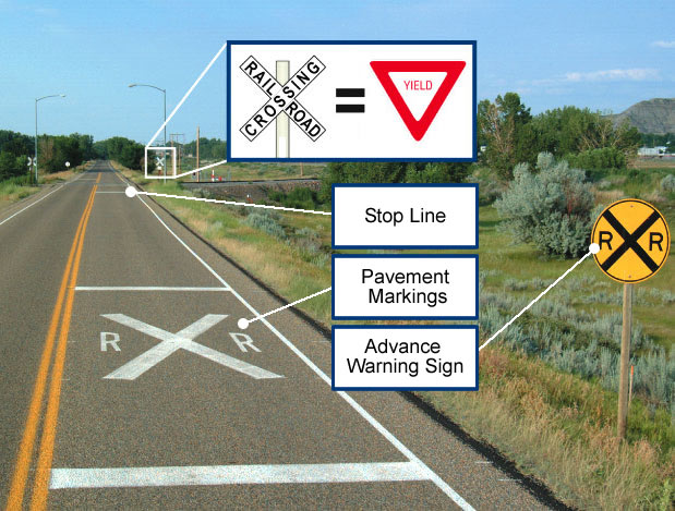 This valid from the middle of the 1960s to today. Mark |
|
Deleted
Deleted Member
Posts: 0
|
Post by Deleted on Mar 14, 2019 17:03:04 GMT -5
Thanks Mark, this brought me much new knowledge about road signs. First, that the pavement markings are white, excepted for the double line in the middle which is yellow. And then, I didn't know exactly the pavement markings at a R-R crossing and the "R X R" signs in front, I only knew the St Andrew's crosses with the two lights ... Other countries, other rules !
|
|
|
|
Post by markm on Mar 14, 2019 20:47:20 GMT -5
In the mid-1960s the center line could also be a solid white as roads were being converted to this national standard.
I should add another possibility for the era prior to the national standard could be a dashed line with a solid line on either side, all white.
|
|


 and it causes no issue to anybody. The last picture of all is unfortunately the less interesting, I saw a German steam loco, and so I think it is a German layout ... or is it the same, only with an other looking angle and some different vehicles ?